
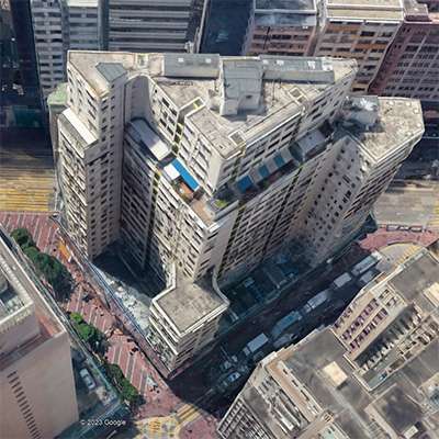
The Footbridge to Nowhere
On Western Street in Sai Ying Pun is a footbridge that makes no sense.
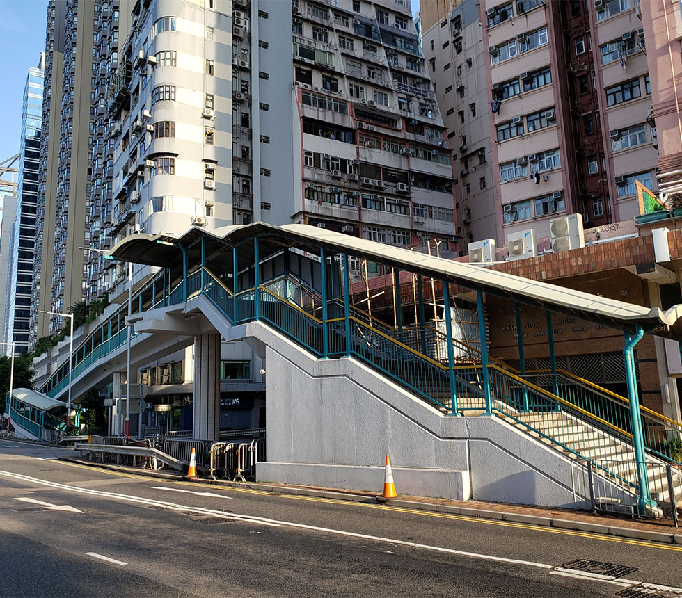
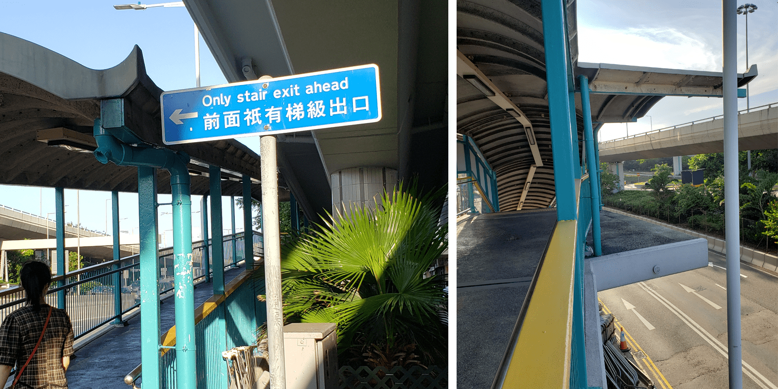
On Western Street in Sai Ying Pun is a footbridge that makes no sense. There is a wheelchair ramp up one side, but only stairs down the other. It is very short, with a span of only 12m excluding the ramp and stairs. Why was this built? One clue is a stub that protrudes towards the waterfront. Was it left unfinished for some reason? In fact, it is the opposite—decades ago, this bridge extended across Connaught Road, but has since been demolished.
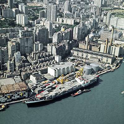
Today, Connaught Road is part of a highway system that extends across Hong Kong Island’s north shore, carrying many lanes of fast-moving traffic. In the early 1970s, it was very different. Connaught Road was on the shoreline, where dock workers loaded goods into warehouses directly across the street. However, between 1973 and 1986, reclamation severed it from the water. The government saw Sai Ying Pun as over-congested, and reclaimed land was needed for infrastructure.
City planning was also becoming increasingly car-centric. The number of registered vehicles in Hong Kong doubled from 144,000 in 1970 to 299,000 in 1980. After conducting a traffic study on Central District between 1982 and 84, the government decided to transform Connaught Road into a “free flow facility…between Harcourt Road [Wan Chai] and Hill Road [Sai Ying Pun]” to relieve traffic congestion in the medium term.
As vehicles would no longer stop for pedestrians, several footbridges would be needed, one of which was the now-truncated bridge at Western Street. The plans were presented to the then-Urban Council in 1985. Aerial photos show that the footbridge was completed in 1989. By 1996, it had been partially demolished. It stood for only seven years. Another bridge nearby on Water Street was demolished and replaced with a street-level crossing. A third bridge on Eastern Street was taken down and rebuilt about 100m away.
Why were such wasteful decisions made? The story here is one of rapid, uncoordinated development. The government had conducted separate planning studies, one on traffic in Central and the other on a possible Western Harbour Tunnel, as if neither had an impact on the other. By 1985 when the Urban Council approved the Connaught Road upgrades, the tunnel study had recommended a route between West Kowloon and the Sai Ying Pun reclamation area the year before. However several more years of transport and feasibility studies would be needed to finalise the Western Harbour Tunnel, so the Connaught Road upgrades proceeded as if it did not exist.
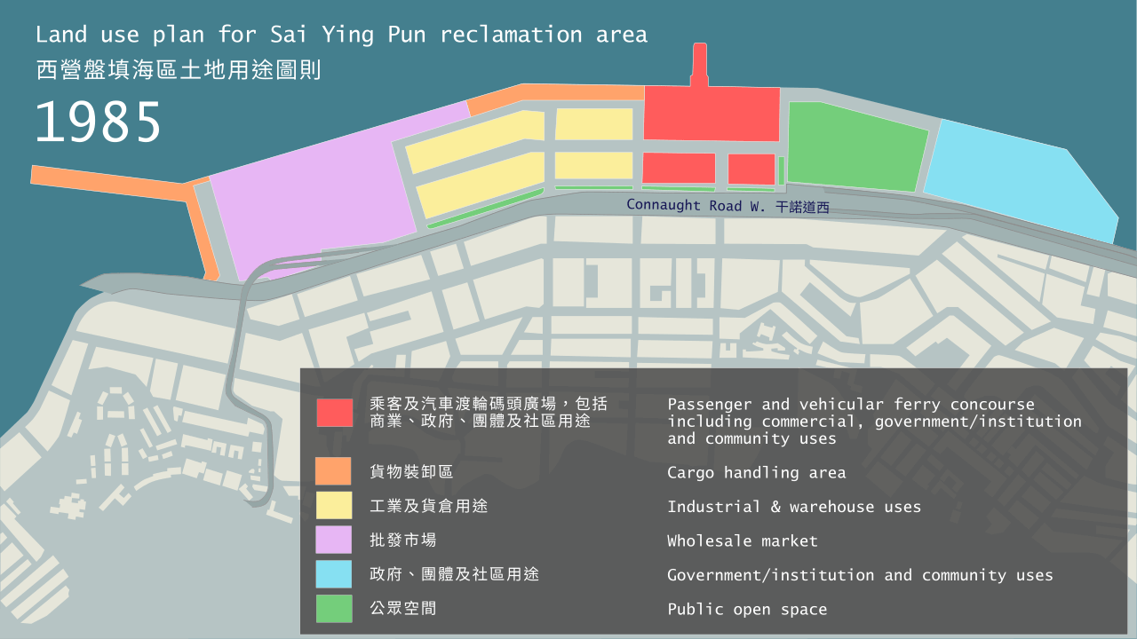
The rapidly changing land use plans of this period further illustrate a lack of joined-up decision making. Traffic engineers made the big decisions, and land use planners reacted. Aside from the widening of Connaught Road, the 1985 pre-tunnel plan for the Sai Ying Pun Reclamation Area was quite pedestrian-friendly and mixed-use. The warehouses on Connaught Road would be relocated opposite a new cargo handling area, a large park was designated, and a new passenger and vehicular ferry terminal with integrated commercial space and community facilities would be built. In those days, planners still anticipated a strong demand for ferries. This explains the need for several footbridges—many people would need to cross Connaught Road daily.
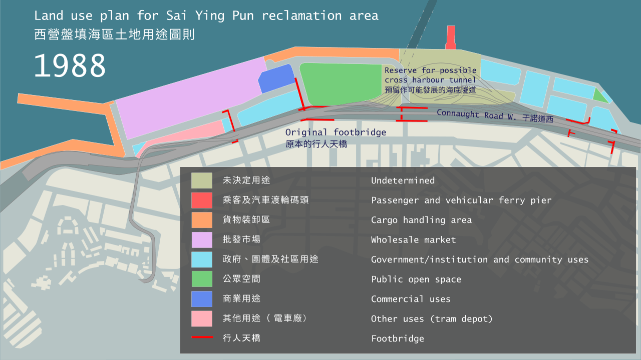
The following year, the Town Planning Board (TPB) added the Western Harbour Tunnel entrance to the plan, marking a large area as “undetermined”. The land use plan from 1988 is an awkward compromise. The TPB did not know exactly where the tunnel would emerge, so the drawings confusingly superimposed a tangle of slip roads over the surface street network. Land uses became more fragmented. The footbridges, which were by then under construction, are shown with one of them right amongst the tunnel slip roads. It is difficult to see how pedestrians could have navigated this mess. Nor, at this point, had planners acknowledged that the tunnel would eliminate the need for the ferry pier. It was shuffled a couple of hundred metres to the east, where it stayed until it was quietly dropped in 1993.
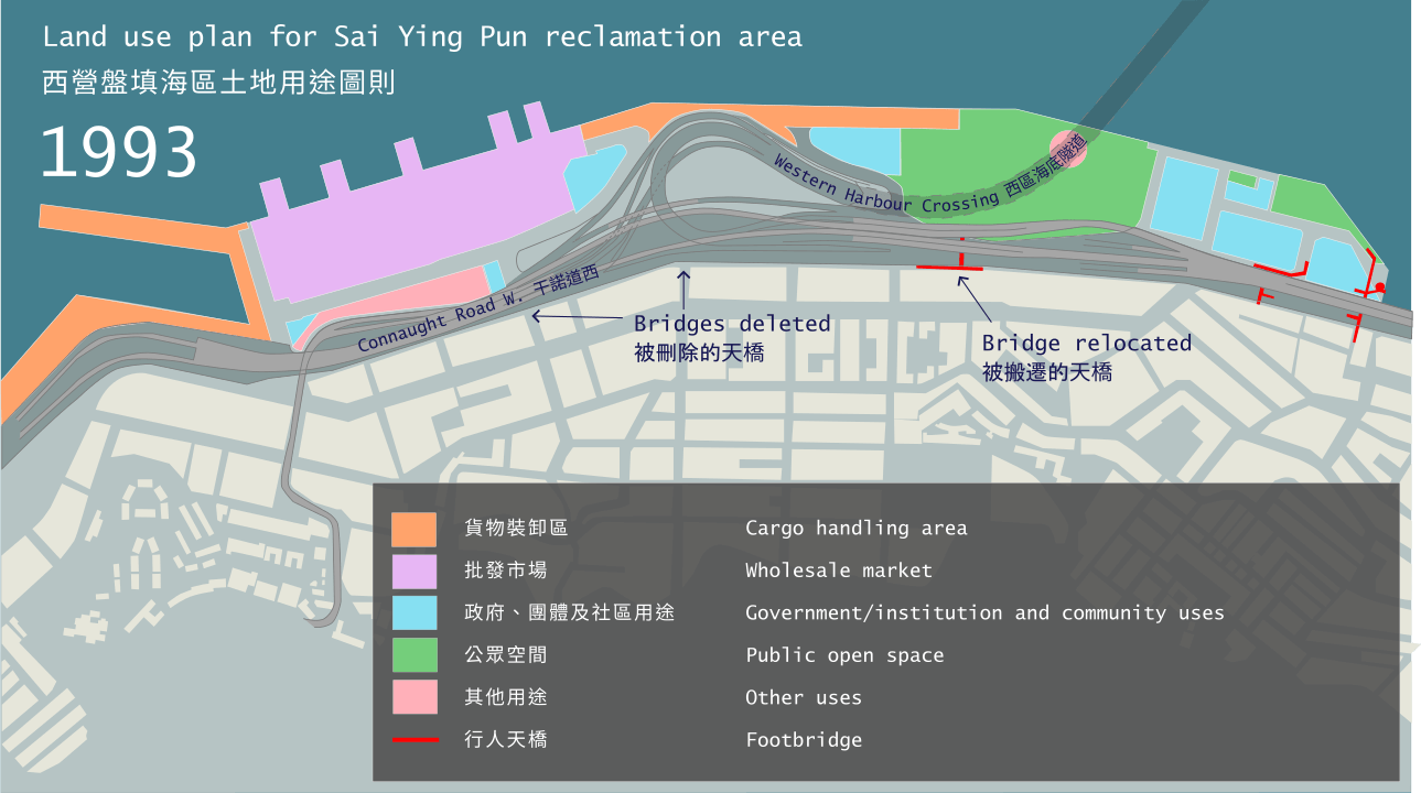
That year, the Western Harbour Tunnel contract was approved by Legco, and the final looping design of the tunnel entrance was added to the land use plan. Two footbridges would have to go, and one relocated. The land was needed for slip roads, and besides, there would no longer be anything to walk to nearby as the tunnel entrance would occupy a 640m stretch of waterfront between the Western Wholesale Food Market and Sun Yat Sen Memorial Park.
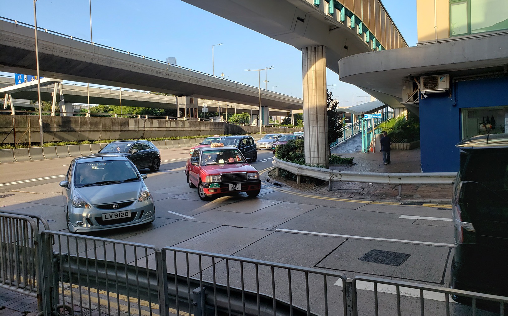
The remaining question is why the Western Street bridge was not demolished completely. What purpose does it serve? Currently, pedestrians are prevented by railings from crossing Western Street at ground level, forced to walk up and down a distance of 100m to cross a 12m wide street. Wheelchair users cannot cross here at all, but must detour one block to the south, an added distance of 120m, which is not much longer than the footbridge. This preserves Western Street as a turn lane for vehicles coming off Connaught Road.
Built to enable the faster movement of vehicles, the Western Street footbridge was superseded by an even bigger road megaproject not long after its completion. It is an unintentional monument to car-centric planning, its remaining leg left in place so that cars can turn left without stopping.
Sources:
- Kathryn Kurek, Joseph Lebenski and David Moquin, “Assessing Urban Development on the Reclaimed Land in Sheung Wan”, student paper, 24 February 2006, Worcester Polytechnic Institute.
- Omega Centre, Centre for Mega Projects in Transport and Development, “Project Profile: Hong Kong, West Harbour Crossing”, 2011, Bartlett School of Planning, UCL.
- Planning Department, Sai Ying Pun and Sheung Wan Outline Zoning Plans Nos. S/H3/1 (1985), S/H3/4 (1988) and S/H3/9 (1993), HKSAR Government.
- Survey and Mapping Office, Hong Kong Government, Aerial photographs nos. 5308 (23 October 1973), A05941 (20 September 1986), A18273 (9 September 1989), A52504 (23 April 1996), courtesy of HKMS 2.0, Lands Department, HKSAR Government.
- Transport Department, “The Annual Traffic Census 2021”, TSSD Publication No. 22CAB1, September 2022, HKSAR Government.
- Urban Council, Capital Works Select Committee, “A Study of the Transportation Requirements of the Mid-levels and Central District”, CAP/123/85, 12 December 1985, Hong Kong Government.
- Urban Council, Environmental Hygiene Select Committee, Recreation Select Committee, Markets and Street Traders Select Committee, Capital Works Select Committee, Culture Select Committee and the Standing Committee of the Whole Council, “Upgraded Connaught Road and Ancillary Roadworks Project,” ENH/42/85, REC 52/85, MST 40/85, CAP/43/85, CUL/35/85, CW/70/85, 8 July 1985, Hong Kong Government.
For the 2024/25 Coastal Trail Challenge, we are collaborating with Parks and Trails to highlight stories behind some..
Perhaps you have seen this somewhere: a set of metal double doors, set into the wall of a..
Part 1 of this series recounted the disappearance of small urban streams that were channelled underground during the..
If you look at an old map of Hong Kong, one of the first things you will notice..