
Hong Kong’s Lost Streams – Part 2: Rivers Lost in Plain Sight
Part 1 of this series recounted the disappearance of small urban streams that were channelled underground during the 19th and 20th Centuries. Yet the rivers and streams that remained above ground have still had their courses and ecosystems profoundly altered by urban development and more than a century of water engineering works. Here in part 2, we will explore the rivers that have been lost in plain sight.
The heavy engineering approach to flood control
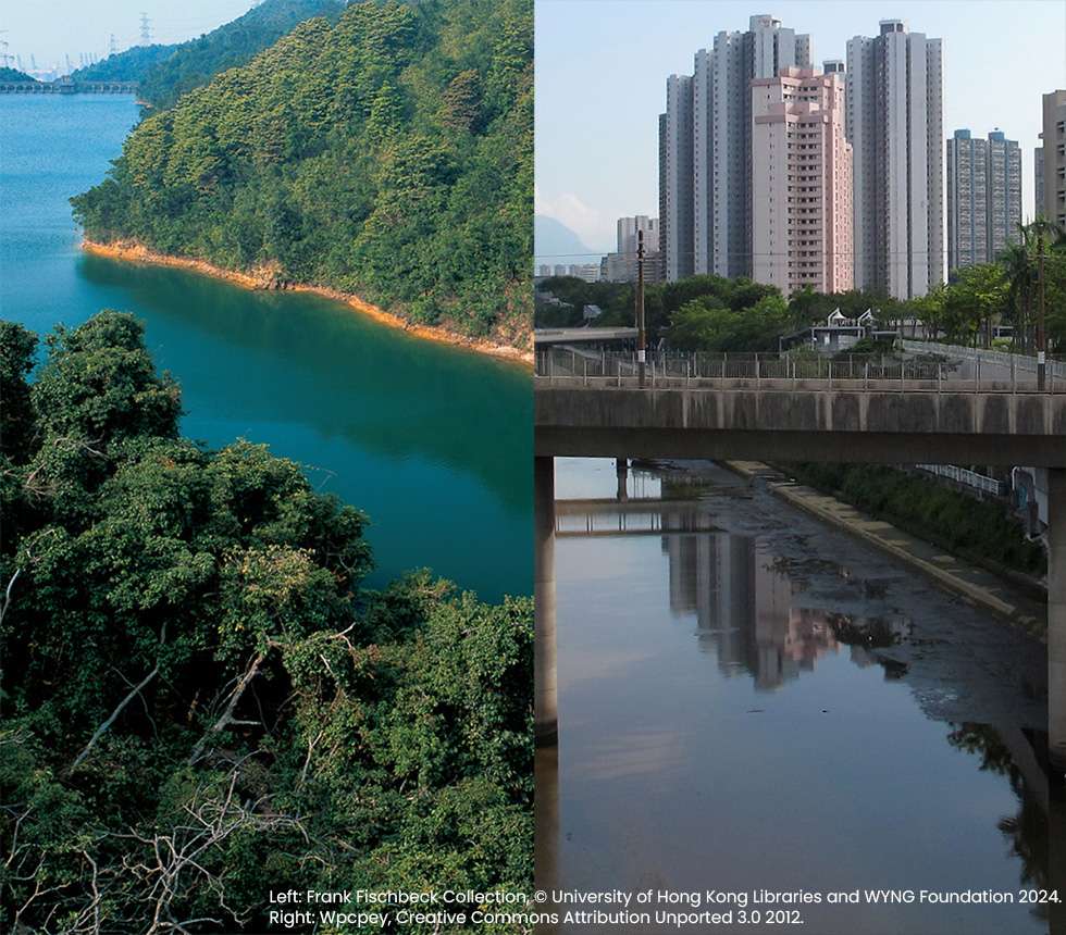
While Hong Kong Island and Kowloon only have small streams, there are several larger rivers in the New Territories, such as the Ng Tung River in Fanling, the Shan Pui River in Yuen Long, the Lam Tsuen River in Tai Po, and the Tung Chung River in Lantau. From the 1960s to the 1990s, their middle and lower reaches were channelized to control flooding. They were straightened, deepened, and lined with concrete to reduce friction. The idea was to get rid of water as quickly as possible. When new towns like Sha Tin were built on reclaimed land, straight, wide artificial channels were dug. The Shing Mun River is mostly man-made.
In nature, a river is a complicated and delicate system. The interactions between moving water, vegetation, sediment and the irregular, porous riverbed affect the water’s temperature, pH and oxygen levels, helping tiny invertebrates break fallen leaves down into nutrients. These factors vary widely within a river, providing diverse micro-habitats for creatures with incredibly specific requirements, from water speed to the type of substrate at the bottom. Concrete channels are too simple to sustain much biodiversity.
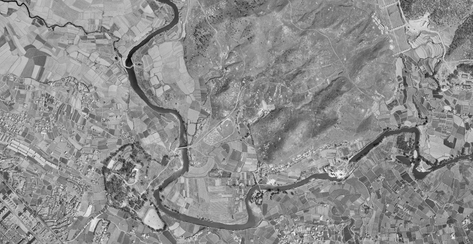
The Ng Tung River in Fanling before channelization in 1963. Source: Lands Department Open Data.
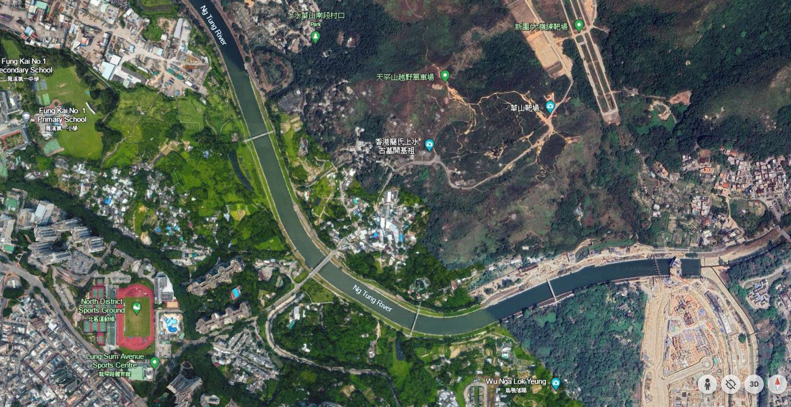
The Ng Tung River in 2024. It was channelized in the 1990s to control flooding. Map data © Google 2024.
Cutting off the flow
Yet, much of the ecological damage had a less obvious cause: the capture and storage of rainwater in reservoirs. Under colonial rule, water shortages were a constant problem. Before 1960 when the government signed an agreement with Guangdong to import water from the Dongjiang River, Hong Kong had to be self-sufficient. With no large rivers, natural lakes, or major aquifers to rely on, the government turned to increasingly ambitious reservoir projects.
To keep up with growing demand, it was critical not just to build more reservoirs, but to ensure that they captured as much water as possible. Catchwaters—long open channels—were built along the contours of hills, so that any mountain streams or surface run-off that flowed into them were channeled towards a reservoir. When the Kowloon Reservoir was built in the early 1900s, a catchwater extending from Kam Shan to Sha Tin Pass was also built. 57 km of catchwaters were built before the outbreak of World War II, with another 63 km built afterwards. Much of this was done with prison labour. Together, the catchwaters encapsulate a third of Hong Kong’s total land area.
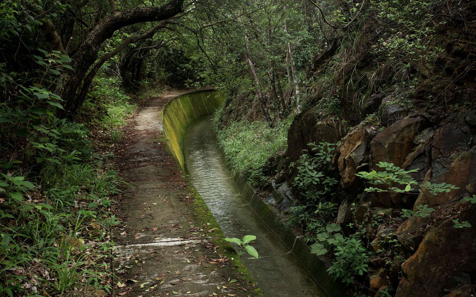
Stanley Mound East Catchwater, first built in the 1920s, directs water towards the Tai Tam Tuk Reservoir. Photo credit: Teddy Ng, 2024.
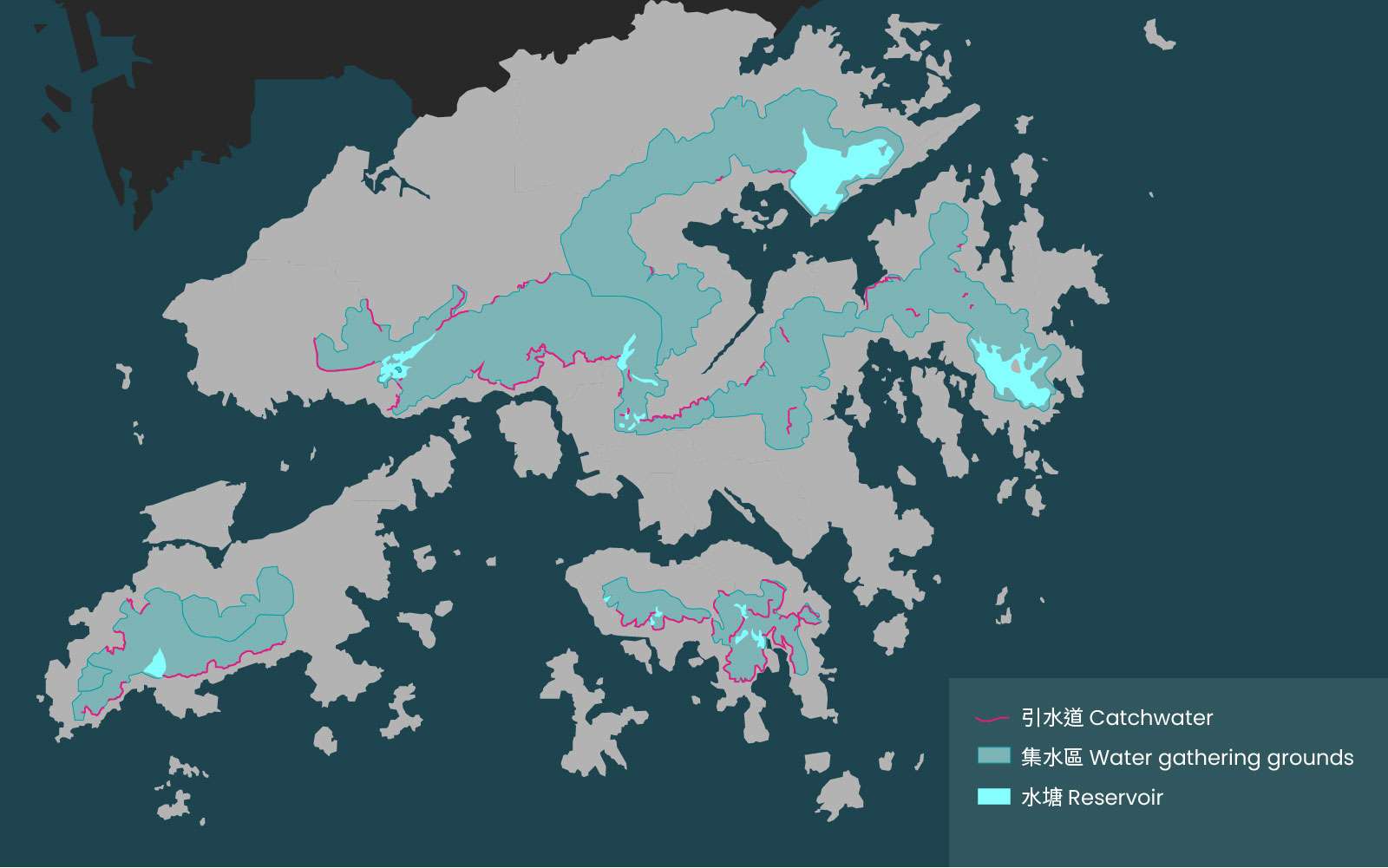
120 km of catchwaters allow Hong Kong’s reservoirs to capture water from one third of its total land area. Sources: Hong Kong Water Centre and Water Supplies Department.
With so much water intercepted, many rivers and streams slowed to a trickle or dried up completely during the winter months. Scientists have a concept of “ecological flow”, which is the minimum amount of water flow needed to sustain a river’s ecosystem. Many of Hong Kong’s rivers now contain too little water during the dry season to keep the aquatic community alive.
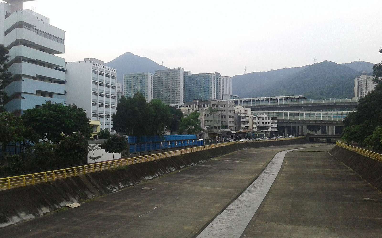
The channelized Tai Wai Nullah during the dry season. It is directly downstream from the Lower Shing Mun Reservoir dam. Photo credit: Underwaterbuffalo, 2016, Creative Commons BY-SA 4.0.
While organisms from upstream can recolonize the riverbed during the rainy season, species that can only live in the lower reaches have nowhere to go. Writing in the mid-1990s, leading local ecologist Dr. David Dudgeon noted that 11 of Hong Kong’s 32 primary freshwater fish species (i.e. fish that spend their whole lives in freshwater) were either threatened with extinction or already extinct. The Water Monitor lizard is believed to have been locally extinct for decades, though there have been some recent sightings of individuals thought to have escaped from the pet trade.
Another consequence is worsening water quality due to there being too little water to dilute pollutants. In addition to the negative impact on humans, this makes the lower reaches vulnerable to pollution-tolerant invasive species such as apple snails and water hyacinth, a floating weed that grows so prolifically that it can cover the entire water’s surface in a matter of days.
Revitalizing rivers
In spite of all the damage, Hong Kong’s streams and rivers are still home to over 190 species of freshwater fish, 20 species of frogs, and 54 species of birds. The Agriculture, Fisheries and Conservation Department has identified the undisturbed upper reaches of 33 streams as ecologically important. This suggests that there is some potential to repair Hong Kong’s river ecosystems, even if they can never be fully restored.
In the last 30 or so years, cities around the world have begun to rethink the way they manage rivers. The Cheonggyecheon river restoration project in Seoul was held up as a poster child. Between 2003 and 2005, the city government demolished an elevated highway, dug up the covered stream, and created an 11 km long river walk. Though it is still a highly engineered waterway dependent on clean water pumped in from the Han River, the project reduced traffic, lowered nearby temperatures by 3°C, and stimulated local businesses. Mayors around the world sought to emulate it.
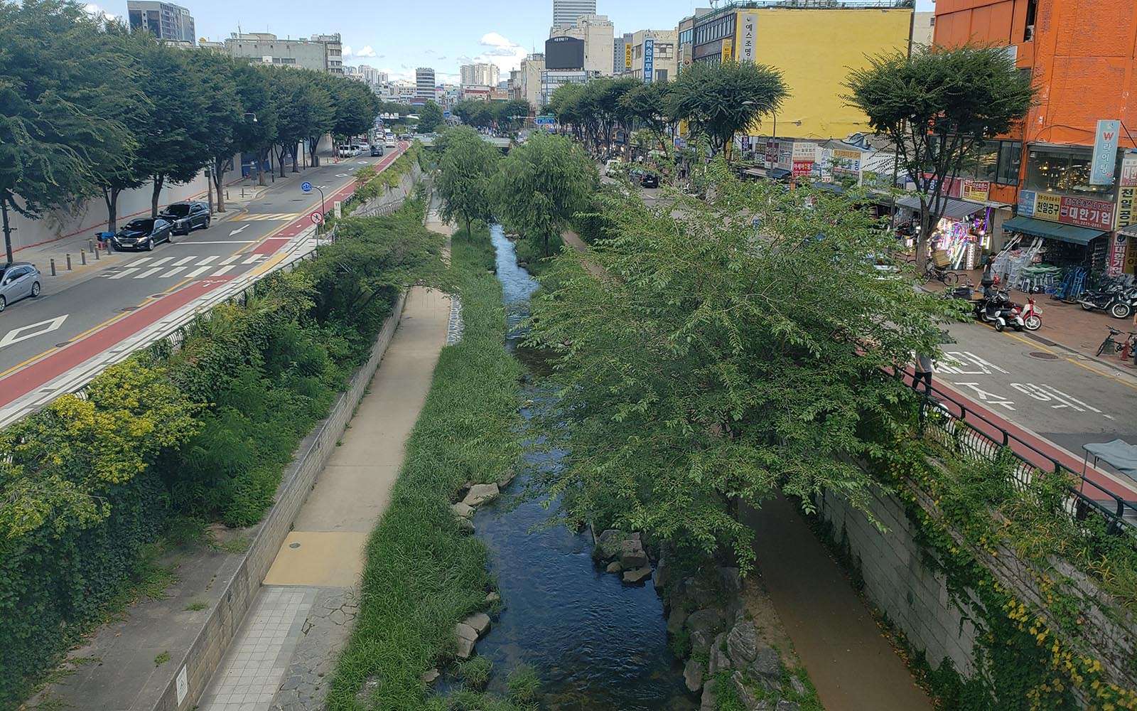
The revitalized Cheonggyecheon in Seoul with pedestrian paths beside the water. Photo credit: Carine Lai, 2023.
In 2015, the Chief Executive’s Policy Address promoted “water-friendly culture and activities” and promised to “revitalize water bodies in large-scale drainage improvement works”. This was followed by the Planning Department’s “Green and Blue Space Conceptual Framework” in 2016. In fact, the Drainage Services Department (DSD) had already been adopting some eco-friendly engineering methods due to pressure from environmentalists since the late 1990s.
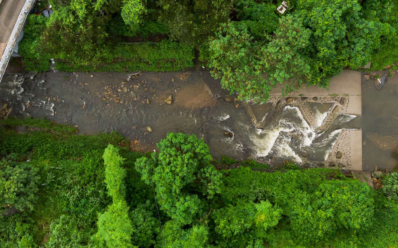
However, the first high profile stream revitalization project was Kai Tak River Improvement Works. The government originally planned to deck it due to complaints about the smell. However, after its water quality improved in the early 2000s, some community groups, academics and district councillors began to advocate for revitalization instead. In 2007, the Kai Tak Nullah was renamed the Kai Tak River, and between 2011 and 2018, the Drainage Services Department expanded its drainage capacity while beautifying the channel with greenery, artificial rocks, submerged planters, and fish shelters.
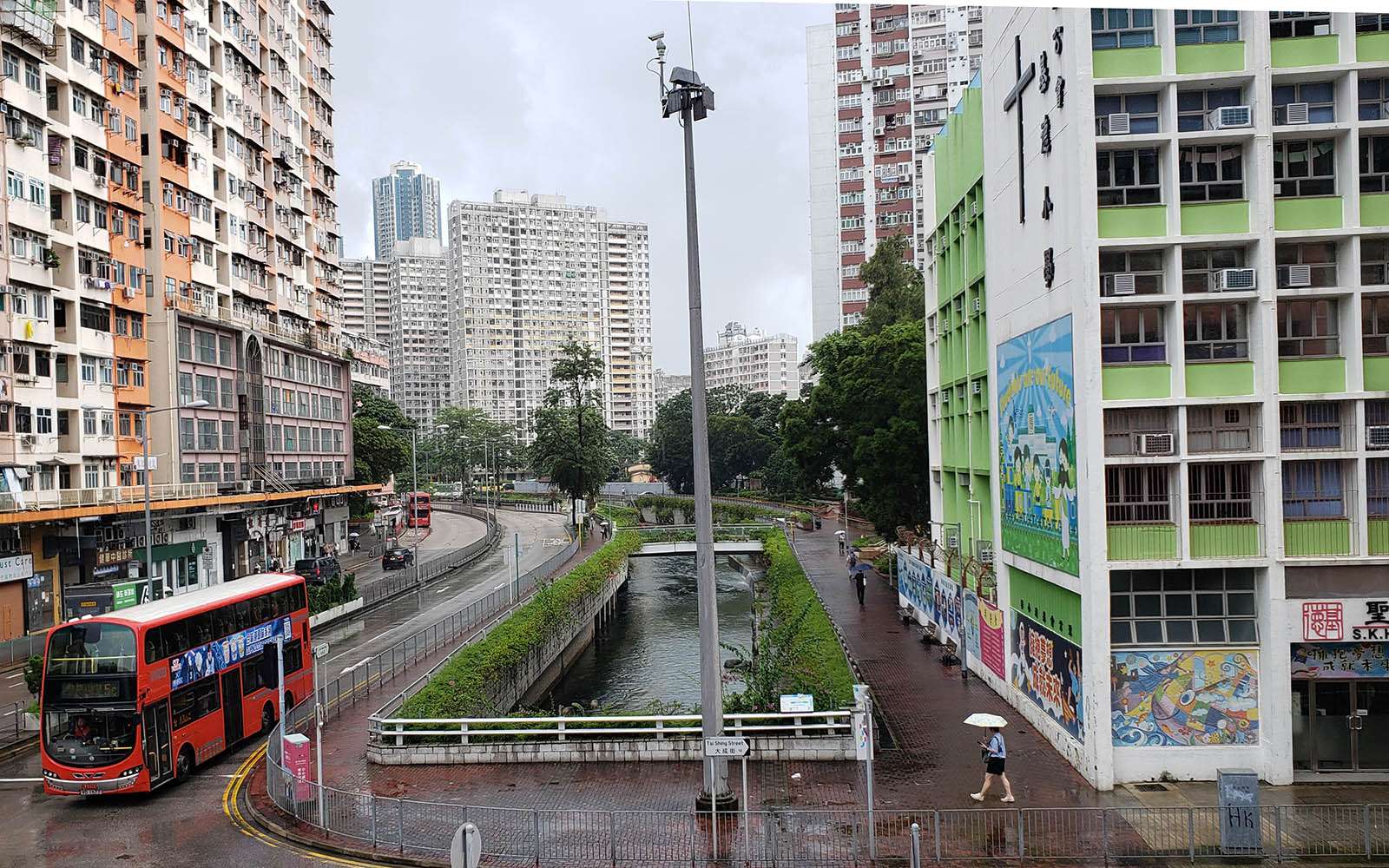
The Kai Tak River is a steep-sided channel in a cramped urban environment. For safety reasons, people are not allowed to enter the channel to walk beside the water. Photo credit: City Unseen, 2024.
However, Dr. Frederick Lee, Executive Director of the University of Hong Kong Water Centre thinks the project was fundamentally misguided. “It’s a drain, not a river,” he says, “but when you call it a river and apply these trendy concepts to it, that causes problems.” An artificial channel since the 1920s, it had no ecosystem left to restore. While fish do live in it now (and neighbourhood residents are often seen fishing) they are mostly exotic species like tilapia. Its main purpose is still to be a storm drain, and during very heavy rains, the planters and artificial rocks are destroyed.
While ecologically poor urban waterways can still benefit humans in terms of microclimate, quality of life, and recreation, Dr. Lee questions whether at a cost of HK$2.8 billion, it was worthwhile. He thinks it would be a far better use of resources to focus on rivers in the New Territories that still have important biodiversity value.
Eco-engineering projects by the DSD in the New Territories try to reproduce natural conditions to make channelized rivers more hospitable to wildlife, for example by installing fish ladders, bird holes, permeable concrete paving that allows plants to take root, building artificial meanders, laying down sand and gravel, and placing rocks of different sizes to vary the water flow. Some of these projects have shown good results: a post-enhancement study of the Lower Lam Tsuen River commissioned by DSD in 2017 found an increase in plant, animal and insect species. However, what these projects can accomplish is limited. Restored habitats are less rich than natural ones, and the community of species can be quite different. Moreover, when eco-engineering is used to mitigate the impacts of ongoing channelization, there is still a net loss.
40m long zig-zag fish ladder built by DSD at the Upper Lam Tsuen River from 2007-12 as part of a stream revitalization pilot project. Photo credit: Joshua Wolper, 2024.
Upstream and downstream divorced
There is a more basic problem that the DSD’s eco-engineering cannot solve: ecological flow. Once water has flowed along a catchwater into a reservoir kilometres away, it cannot be sent back, so the only way to allow rivers to flow again is to dismantle catchwaters. Dr. Lee proposes that this should be done selectively after careful study.
Hong Kong can afford to let more water flow downstream, since we now buy 70-80% of our water from the Dongjiang River. There has not been water rationing since 1982, and in most years we do not use up the 820 million cubic metres allocated to us. Of Hong Kong’s 17 reservoirs, the four largest—High Island, Plover Cove, Tai Lam Chung and Shek Pik have 96% of the storage capacity. Decommissioning the smaller ones would barely make a dent.
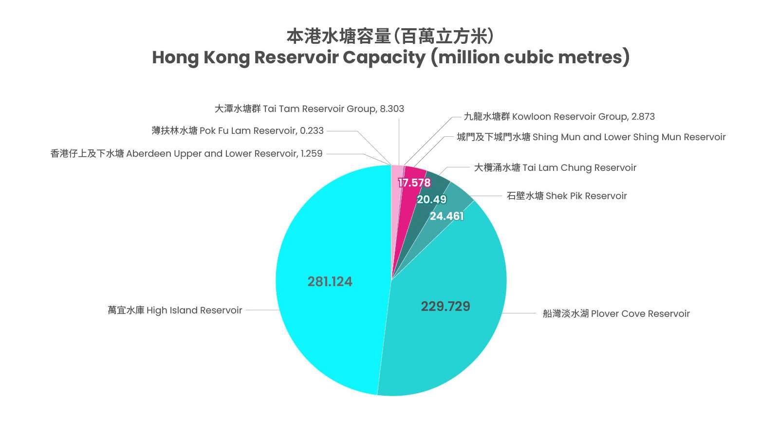
Source: Water Supplies Department, 2024.
The main obstacle is not practical, but administrative. In the mainland, cities like Beijing and Guangzhou have allocated a certain amount of water to minimum ecological flow. Hong Kong has no such policy because it has no holistic river basin management. The WSD handles water supply and distribution, while the DSD handles flood control and wastewater treatment. While this seems logical from a municipal services standpoint, it is nonsensical from a river basin standpoint. River basins are arbitrarily cut in half, with WSD managing them above the catchwater line, and DSD managing everything below. DSD therefore cannot demolish catchwaters, and WSD has no responsibility to do so.
The one place where DSD has “solved” ecological flow is the Kai Tak River, which is consistently fed by the output of the Sha Tin Sewage Treatment Works, via a pipeline drilled through the Kowloon Hills in the 1980s-90s to clean up Tolo Harbour. The treated sewage was too polluted for Tolo Harbour (which resulted in red tides, an overgrowth of phytoplankton), but was less polluted than the Kai Tak Nullah at the time. The fact that the Kai Tak River no longer dries up was a side benefit of the project, but not a generalizable solution.
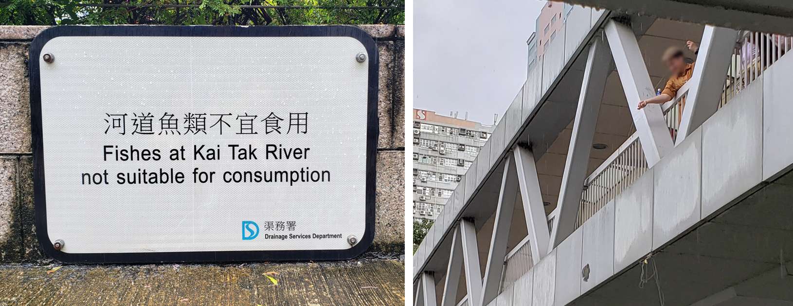
Left: Sign at Kai Tak River warning people not to eat the fish caught there. Right: A person fishing in the Kai Tak River from an overhead footbridge on a rainy day. Photo credit: City Unseen, 2024.
In an ideal world, the WSD and DSD would be merged into a single water authority. However, this would require a shift in perspective in top policymakers. They would have to appreciate that for all our advanced engineering, an urban society like Hong Kong is still situated within broader natural systems. We are all part of the water cycle, from watershed to estuary.
Sources:
Yixin Cao, Wendy Yan Chen and Karl Matthias Wantzen, “‘One River, Two Systems’: Hong Kong’s River Management”, Environmental Management, January 2024, v.71 i.1, pp.81-101.
Yang Chen, “Assessment of the Environmental, Ecological and Social Impacts of River Restoration Projects in Hong Kong”, PhD thesis, Department of Civil and Environmental Engineering, Hong Kong Polytechnic University, August 2023.
Luk-ki Cheung, “Back-to-Basics—Simple Principle but Complex Manipulation for Hong Kong Rivers”, presented at the International Symposium on Water Sustainability, 2022.
Drainage Services Department, “2021-22 Sustainability Report—City Rivers Communion,” HKSAR Government, 2022.
David Dudgeon, “Anthropogenic Influences on Hong Kong Streams”, GeoJournal, 1996, v.40, pp. 53–61.
Hong Kong Water Centre, “Water Resources in Hong Kong”, Centre for Water Technology and Policy,
The University of Hong Kong, 2024.
JC-Wise Water Initiative on Sustainability and Engagement, Rivers@HK Database, 2024.
In-keun Lee, “Cheong Gye Cheon Restoration Project”, Seoul Metropolitan Government, presented at Local Governments for Sustainability World Congress, 2006.
Declan McCabe, “Rivers and Streams: Life in Flowing Water”, Nature Education Knowledge, 2011, 3(10):19.
Florence Mok, “Catchwater colonialism: reshaping Hong Kong’s hydrology, infrastructure, metabolism and landscape, 1937–1968”, Urban History, May 2024, v.51 i.2, pp.1-18.
Mott McDonald, “Eco-hydraulics study on green channels of Hong Kong”, 2017.
An abandoned, hollowed out fire hydrant sits by an overgrown path in a forest. Its red paint, though..
If you walk down main roads in the New Territories, you might notice buildings called “Vegetable Depots” near..
If you follow the Western Harbour Walk on the Hong Kong Island Coastal Trail, you will pass the..
The year is 1869. Hong Kong has been under British rule for 28 years, and it has been..
For the 2024/25 Coastal Trail Challenge, we are collaborating with Parks and Trails to highlight stories behind some..