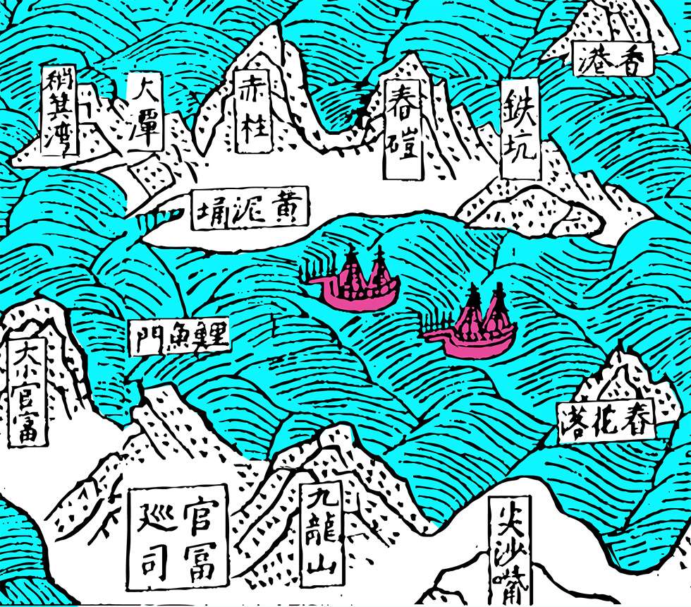
Ming Dynasty map of the Hong Kong coastline, Yue Daji, 1590s. Coloured by City Unseen.
Ming Dynasty map of the Hong Kong coastline, Yue Daji, 1590s. Coloured by City Unseen.
On a map of Hong Kong published almost 430 years ago in the Ming Dynasty book Yue Daji (“The Grand Record of Guangdong”), one can spot several familiar place names including Shau Kei Wan, Tseung Kwan O and Tsim Sha Tsui. Many of these places were named after natural landscape features which after 170 years of reclamation, no longer exist. Today, these names do not evoke much beyond stops on the MTR, but when you look at Hong Kong’s original coastline, they suddenly make sense.
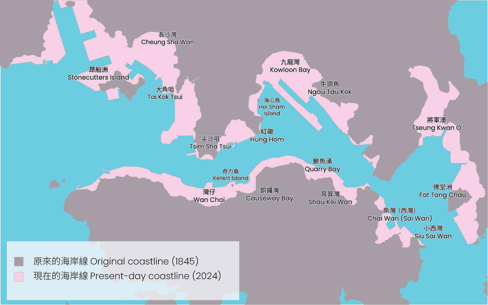
Sources: OpenStreetMap, hkmaps.hk. Drawn by City Unseen.
Many neighbourhoods have “Bay” or “Wan” (灣) in their names, from bays that have been reclaimed. “Cheung Sha Wan”, which means “long sandy bay” was shown as a beach on 19th Century maps. Kowloon Bay was a wide, shallow bay that was gradually reclaimed starting in the 1920s, culminating in the construction of the Kai Tak Airport runway in the 1950s.
Cheung Sha Wan beach, from map by Lieutenant E.G. Young, R.E., 1890. Source: UK National Archives. Public domain image.
It is not known which military leader Tseung Kwan O, which means “General Cove”, was named after. Today it is no longer a cove, having been reclaimed in the 1990s to build Tseung Kwan O New Town, Tseung Kwan O Industrial Estate, and the South East New Territories Landfill.
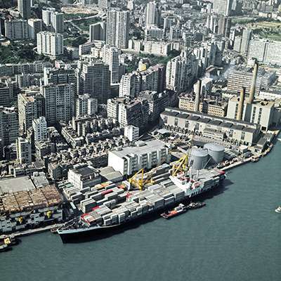
On Hong Kong Island, a string of bays were filled in as reclamation expanded eastwards from Sheung Wan starting in the 1850s. Reclamation reached Wan Chai (“Little Bay”) by the 1920s, and two more phases in the 1970s and in the 2010s extended its coastline further northwards. Reclamation filled Causeway Bay in the 1950s to create Victoria Park, Quarry Bay in the 1980s for the construction of the Island Eastern Corridor, and Shau Kei Wan and Chai Wan in the 1980s and 1990s for the construction of housing estates and the MTR Island Line.
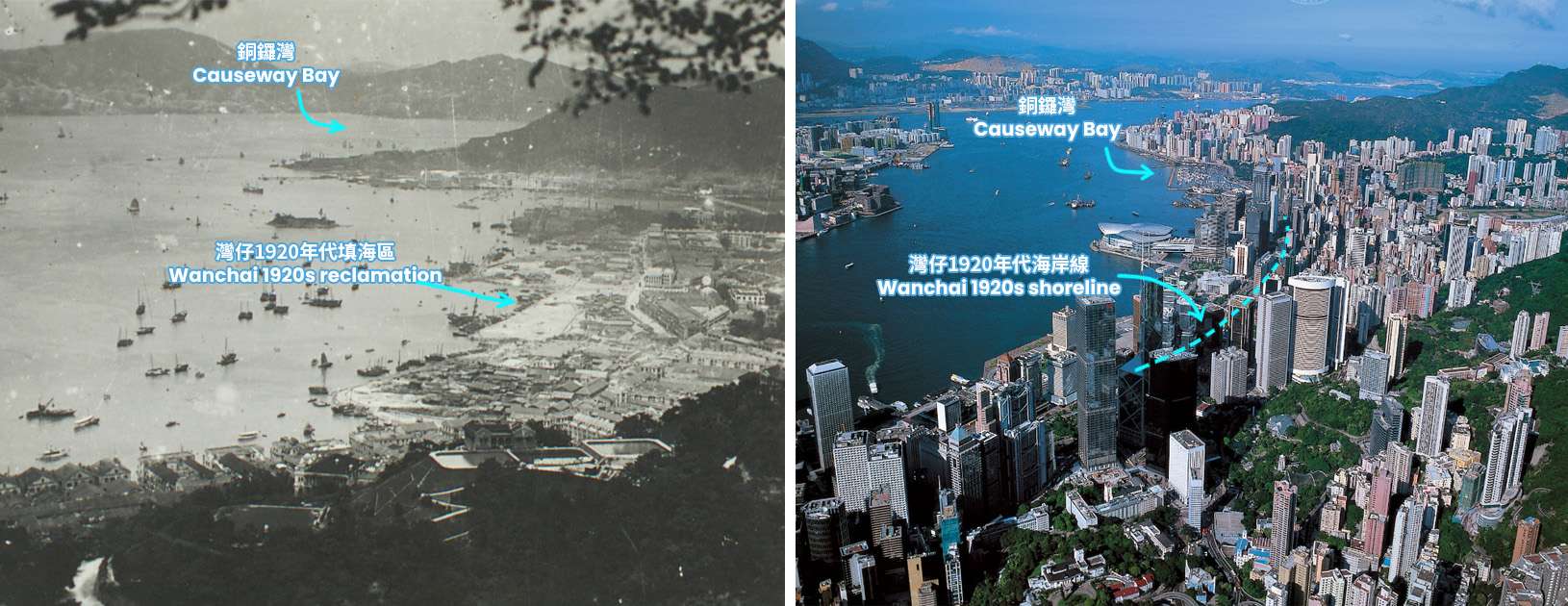
Left: Wan Chai and Causeway Bay in 1921. Right: Wan Chai and Causeway Bay in around 2004. Copyright © 2024 The University of Hong Kong Libraries and WYNG Foundation. All rights reserved.
Colonialism imposed some English names that had nothing to do with their Chinese counterparts. While Chinese names usually described the landscape, English names came from people, structures, or activities that were important to the colonists.
For example, Causeway Bay’s English name refers to the causeway—a raised embanked road—that was built across the low-lying mudflat towards North Point in the 1850s. Its Chinese name, Tung Lo Wan (“Copper Gong Bay”) refers to its rounded shape.
The English name Quarry Bay comes from stone quarries established by Hakka people shortly after the arrival of the British. Local granite was important for construction and became a significant export. The Chinese name Chak Yue Chung (“Carp Stream”) does not refer to the bay at all, but to the fish that were once common in the stream that used to flow into it, before it was channeled underground.
The Chinese name Shau Kei Wan (“Winnowing Basket Bay”) comes from its resemblance to baskets that were used to dehusk rice. In English, it was named Aldrich Bay after British military engineer Major Edward Aldrich, who led a naval assault on seven forts outside Guangzhou in 1847.
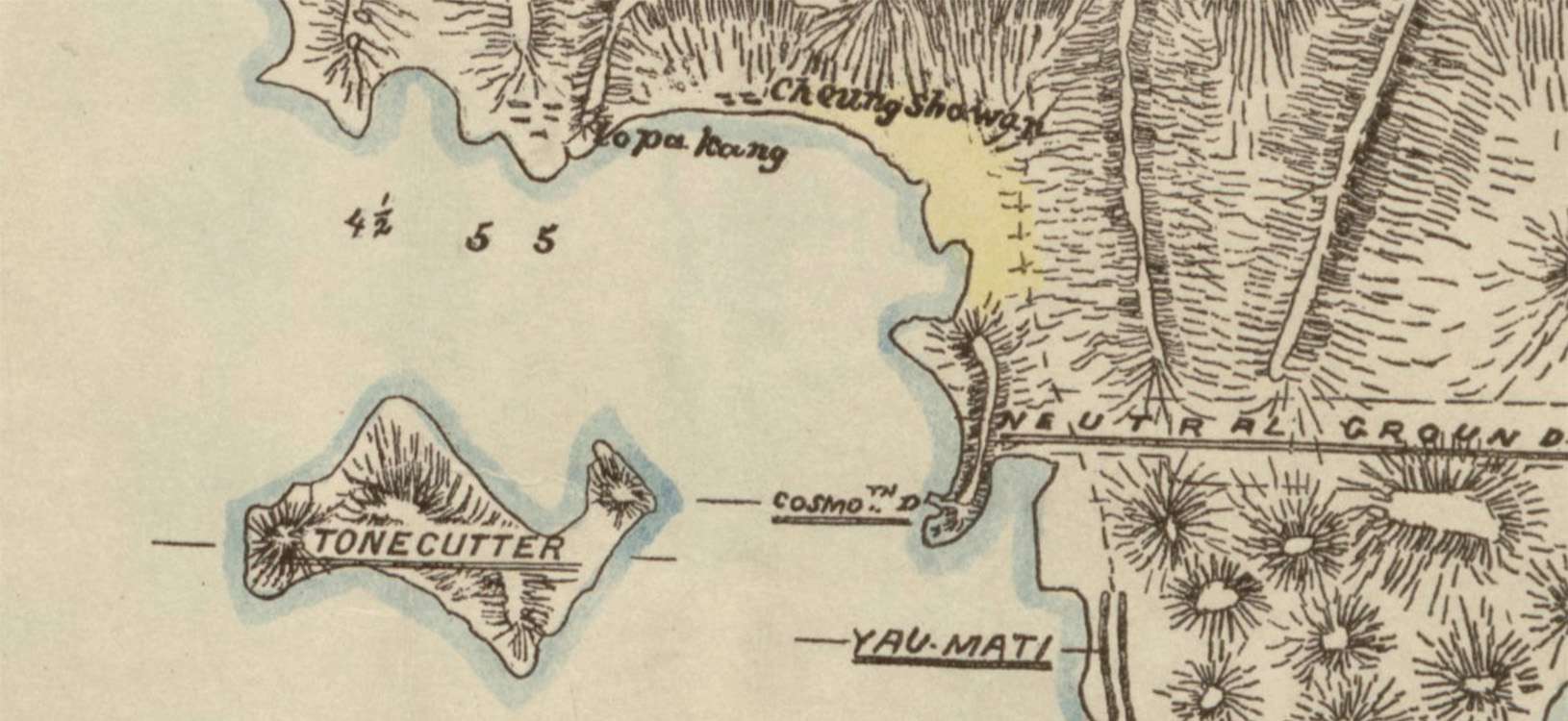
On eastern Hong Kong Island, Chai Wan (“Firewood Bay”), used to be known as “Sai Wan” (“Western Bay”). This incongruous naming may have been the result of linguistic confusion.
The name “Chai Wan” is thought to have been derived from the abundant firewood used to fuel the local ceramics industry in the Qing Dynasty. However, when British Lieutenant T.B. Collinson first surveyed Hong Kong in 1845, he labelled it “Sywan Bay”, and the nearby smaller bay “Little Sywan Bay”. He probably mixed up the syllable “chai” (柴 firewood) with “sai” (西 western), and also seems to have been unaware that “wan” meant “bay”, making his label redundant (“Western Bay Bay”).
Regardless of the reason, “Sai Wan” stuck, and was often (but not always) used on maps until the 1960s. To this day, the neighbourhood built on the nearby smaller bay is known as Siu Sai Wan (Little Western Bay), not Siu Chai Wan (Little Firewood Bay).
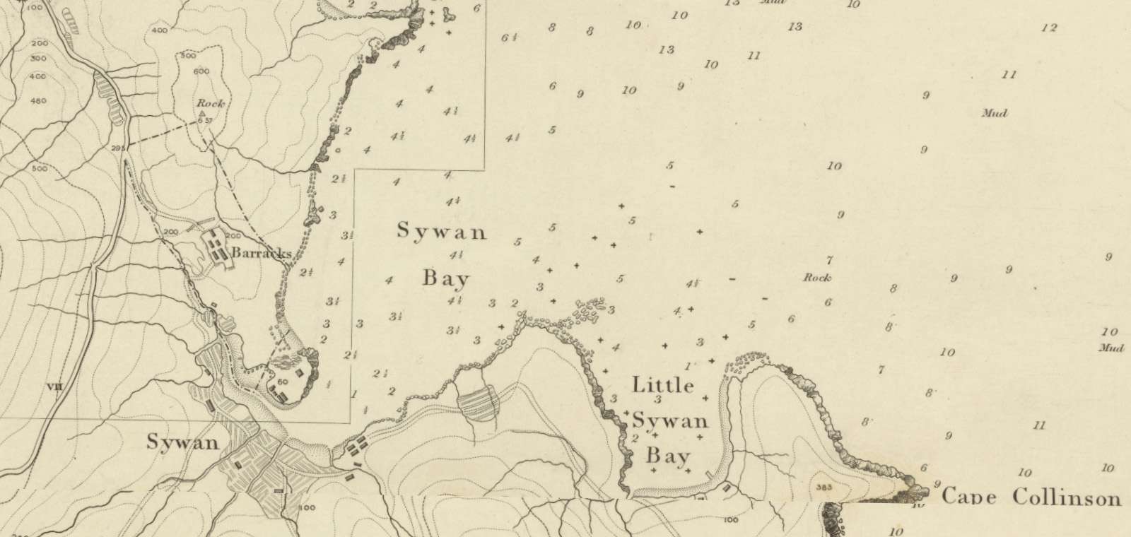
Chai Wan and Siu Sai Wan labeled “Sywan Bay” and “Little Sywan Bay” on the Ordnance Map of Hong Kong, 1845, by Lieutenant T. B. Collinson. Source: hkmaps.hk
In Chinese, peninsulas are called “tsui” (嘴/咀), literally meaning lips or beak; or “kok” (角) meaning corner. Hence, Tai Kok Tsui (“Big Corner Beak”) was once a narrow rocky promontory just south of Sham Shui Po. Ngau Tau Kok (“Cow Head Corner”) was a hilly peninsula with a prominent rock said to resemble an ox horn.
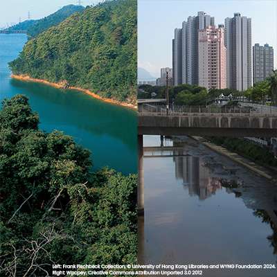
The name Tsim Sha Tsui literally means “Sharp Sandy Beak”. The peninsula was once much narrower—the Kowloon Canton Railway ran along its eastern shore parallel to Chatham Road down to the rail terminus, where the clock tower remains. East Tsim Sha Tsui was reclaimed between the 1950s and the 1970s, while the remainder of Hung Hom Bay was reclaimed in the 1980s and 1990s.
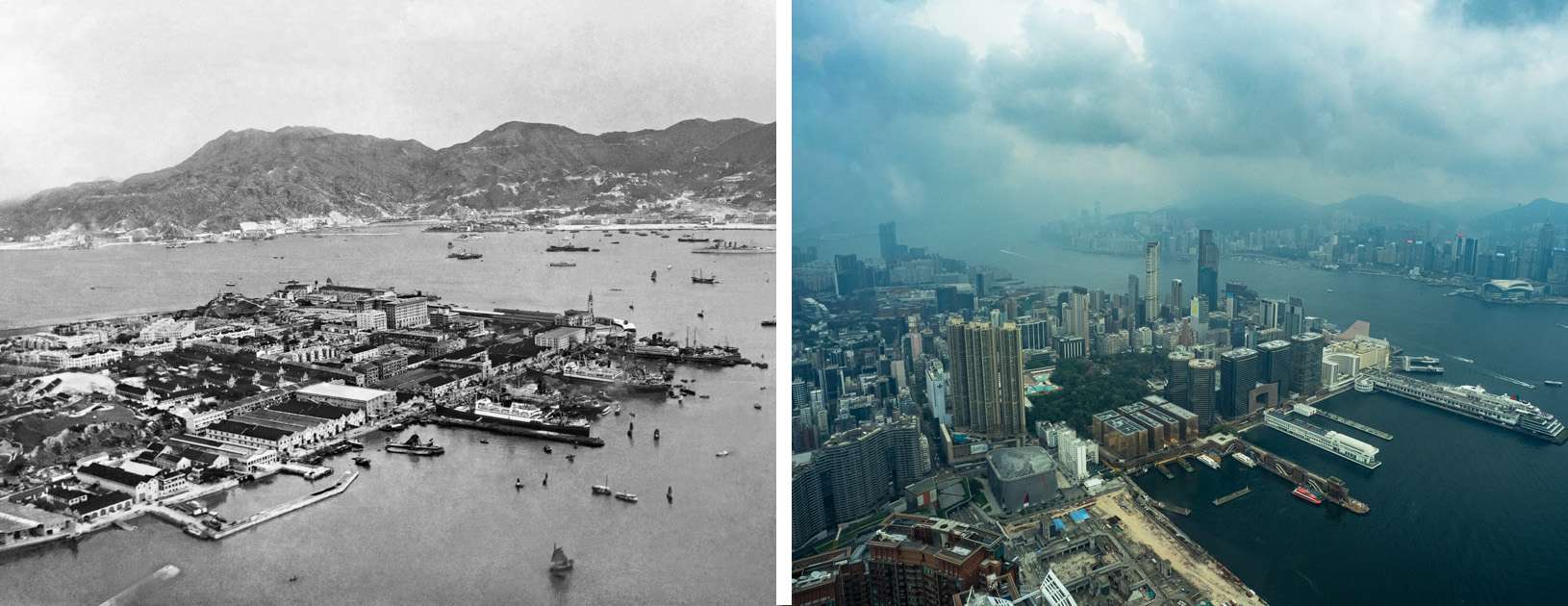
Left: Aerial view of Tsim Sha Tsui peninsula in the 1920s. Copyright © 2024 The University of Hong Kong Libraries. All rights reserved. Right: View of Tsim Sha Tsui from the same angle taken from the observation deck of ICC, April 2024. Photo credit: Joshua Wolper. and WYNG Foundation.
“Hung Hom” means “red cliffs”. There was once a 75m high hill with steep slopes down to the shoreline. In the 1860s, the Hong Kong and Whampoa Dock was built at the bottom of the hill where Whampoa Garden is now. By the 1880s, maps showed extensive quarrying in the area, which remained well into the 1970s until the redevelopment of the dockyard. Today, the remnants of the hill can be found at Hutchinson Park.
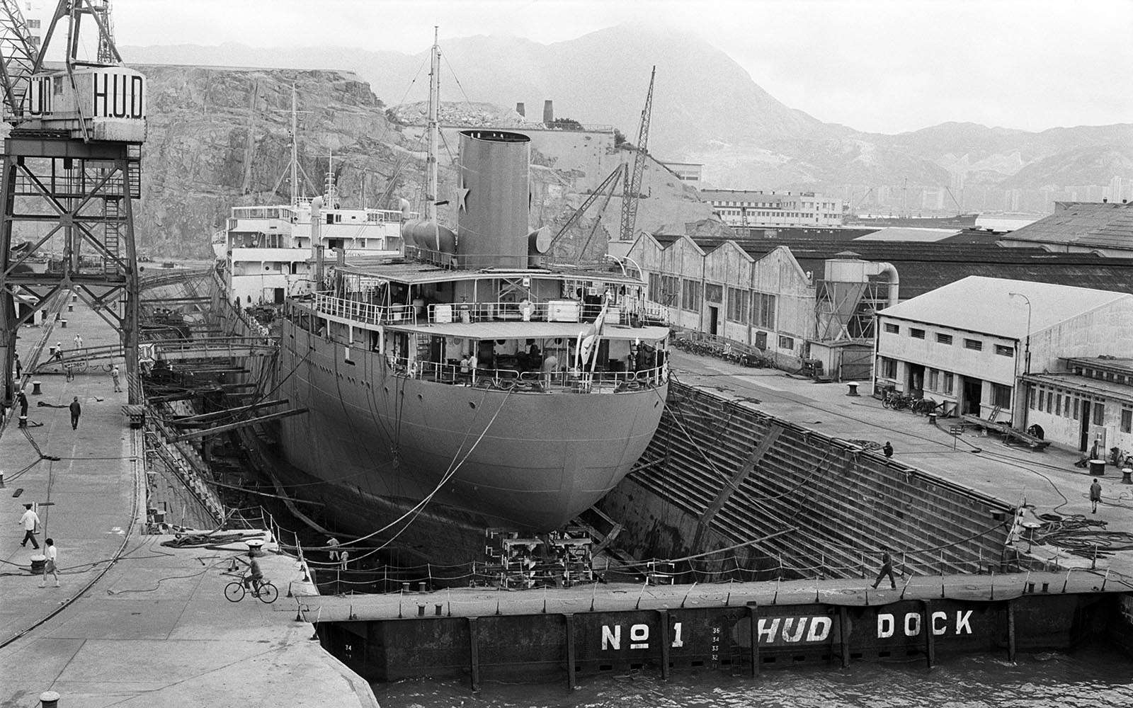
Cliffs visible behind the Hong Kong and Whampoa Dock, c. 1970s. Copyright © 2024 The University of Hong Kong Libraries and WYNG Foundation. All rights reserved.
The process of reclamation also engulfed several islands whose names still retain the words “Island” in English or “Chau” (洲) (river or delta islet) in Chinese, despite no longer being surrounded by water.
Kellet Island, named after British naval officer Sir Henry Kellet, and the site of the Royal Hong Kong Yacht Club since 1939, is now located next to the Causeway Bay Cross Harbour Tunnel entrance. Hoi Sham Island (“Middle of the Sea Island”) was once home to a temple; now all that remains of it are two boulders in To Kwa Wan’s Hoi Sham Park. Fat Tong Chau (“Buddhist Hall Island”) had a small village that was relocated during the reclamation of Tseung Kwan O. It is now a green hill surrounded by industrial buildings and landfill.
Ngong Shuen Chau (“Capsized Boat Island”), named Stonecutter’s Island in English, was a stone quarry in the 19th Century, then used as a military facility from the 1930s onwards. It was joined to Kowloon in the 1990s with the expansion of the Kwai Chung Container Terminal and the construction of road and bridge links to the new Chek Lap Kok airport. It is now the site of a People’s Liberation Army naval base, a government dockyard, and a sewage treatment plant.
Hong Kong’s coastline is much straighter and flatter than it was 170 years ago, yet some places have retained names that are much older. It makes you wonder if in 400 years’ time, people will be wondering about the origins of place names like “Olympic” and “LOHAS Park”.
Vivian Go, “Mapping the History of Land Reclamation in Hong Kong”, oldhkphoto.com, 2014.
Hugh Farmer, “Quarrying and transportation of stone in Hong Kong, 1841”, The Industrial Historyof Hong Kong Group, 21 February 2014.
South China Research Centre, “Story of the Bay: Tseung Kwan O and Hang Hau”, University of Science and Technology, 2022.
Ho Puay-peng et al., “Heritage Impact Assessment on Chai Wan Factory Estate at No. 2 Kut Shing Street, Chai Wan, Hong Kong”, Hong Kong Housing Authority, April 2013.
For the 2024/25 Coastal Trail Challenge, we are collaborating with Parks and Trails to highlight stories behind some..
Perhaps you have seen this somewhere: a set of metal double doors, set into the wall of a..
Part 1 of this series recounted the disappearance of small urban streams that were channelled underground during the..
If you look at an old map of Hong Kong, one of the first things you will notice..