
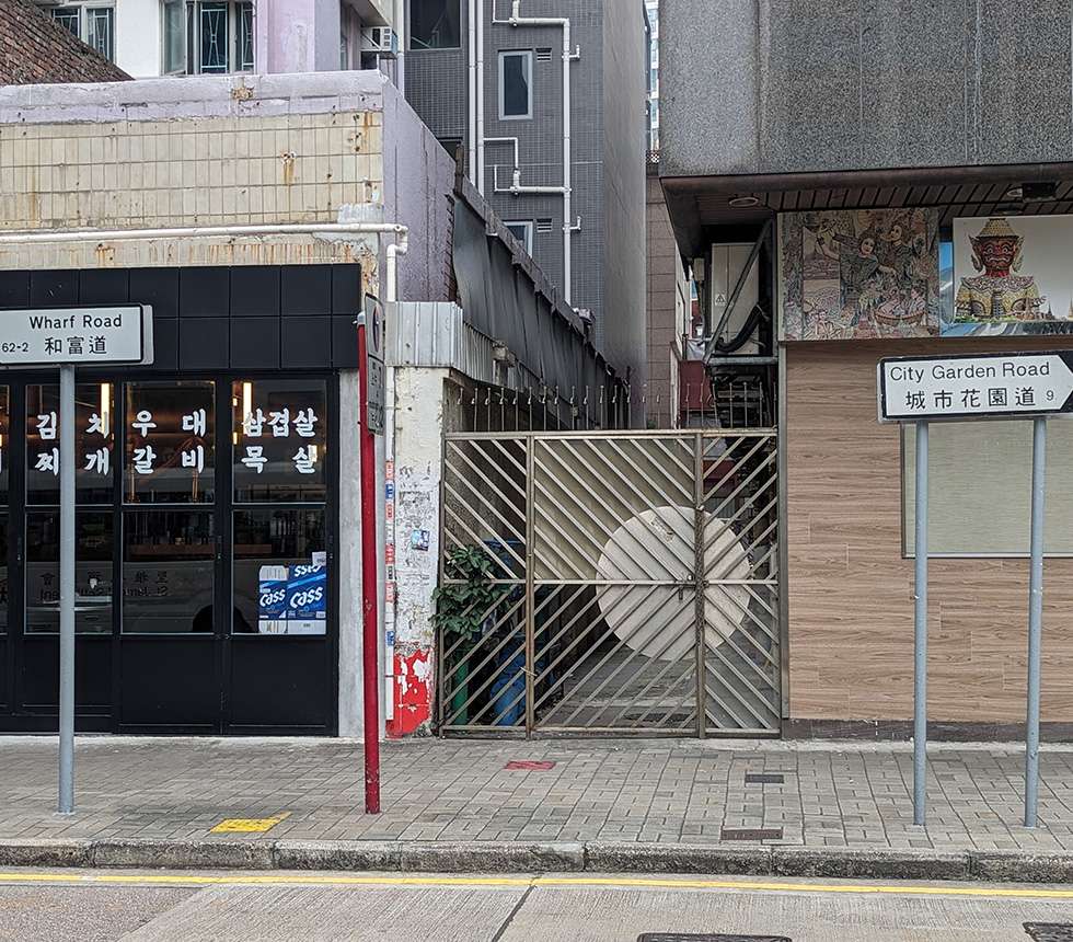
On the same street, the signs for ‘Wharf Road’ and ‘City Garden Road’ are just a few metres apart. Photo credit: City Unseen.
On the same street, the signs for ‘Wharf Road’ and ‘City Garden Road’ are just a few metres apart. Photo credit: City Unseen.
In North Point, Wharf Road and City Garden Road are named after two adjacent private housing estates, even though they are technically the same street. Their street signs stand side by side just a few metres apart. According to Geoinfo Map, the dividing line is at the Po Leung Kuk Yu Lee Mo Fan Memorial School, with Wharf Road extending to the east and City Garden Road to the west. Why does a continuous street change its name midway? To answer this, we have to look into its origins.
In 1948, China Provident Co. built the North Point Wharves on a piece of newly reclaimed land in North Point. Three years later, the government named its dead-end access road “Wharf Road”. In the late 1970s, the wharves were demolished with plans to redevelop the site into a large private housing estate, named Provident Centre in English and 和富 (wo fu, a homophone for “wharf”) in Chinese.
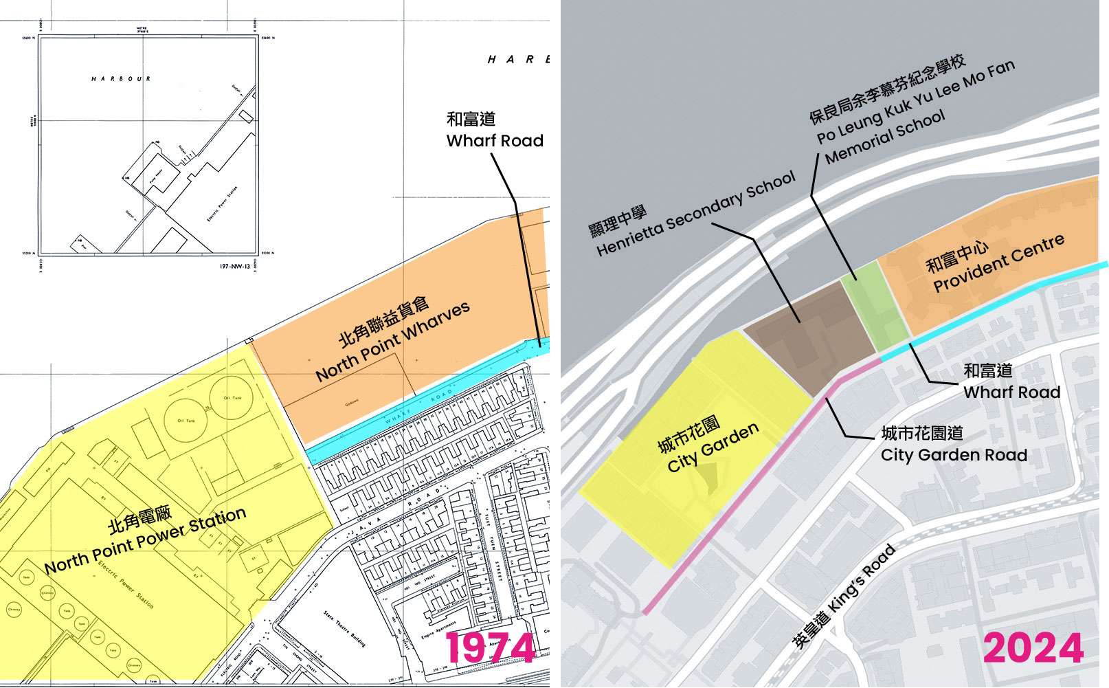
Left: Survey sheets, 1974. Wharf Road was a dead-end road serving the North Point Wharves and leading to the North Point Power Station. Source: Lands Department Open Data. Right: In 2024, the dividing line between Wharf Road and City Garden Road is in front of the Po Leung Kuk Yu Lee Mo Fan Memorial School. Source: OpenStreetMap.
Next door to Provident Gardens was the North Point Power Station which began operations in 1919. In the early 1980s, the site was redeveloped into another large residential estate, City Garden, with a private road through it that connected to Wharf Road. When the government took over management of the private road in the early 1990s, there were discussions among government departments about what to name it. The Commissioner of Chinese Language, Postmaster General, and Chief Highway Engineer wanted to name the street “Shing Shi Road” (a homophonic translation of City Road). They objected to “City Garden Road” because that sounded too much like a private road, and because it might be confused with Garden Road in Central.
However, in a strongly-worded letter to the District Officer of Eastern District, the City Garden Owner’s Committee advocated for “City Garden Road”. The District Officer passed their concerns on to the Urban Services Department, which was then responsible for street naming. The Owner’s Committee reasoned that City Garden was a well-known development and a landmark of the North Point area. Naming the road after it would help people easily locate it and relate it to the surrounding neighbourhood. The residents won; in 1992, the road was officially gazetted as “City Garden Road”.
The time gap between the construction of Wharf Road and City Garden Road was almost 30 years, and the gap between their naming was almost 40 years. They each symbolize the industrial past and economic transformation of North Point, reflecting the area’s changing land uses. Archival documents do not reveal why the government did not consider applying one name to the whole street, but the direction of the building numbers offers some clues. Wharf Road’s building numbers begin at the point where City Garden Road was attached, ascending towards the east. If the newly handed over public road became part of Wharf Road, then every building on the original Wharf Road would have to be renumbered. All businesses and residents would have to change their addresses, inconveniencing citizens’ everyday lives, government administration, and management.
It may seem logical for a road to keep the same name throughout its length, but street naming has to take into account the impact on residents, businesses, the general public, public services, and even land leases. Therefore, the government generally will not change well-established street names unless there are very good reasons. Sometimes, to avoid disruption, extensions of an existing road might be given a separate name.
Source: OpenStreetMap.
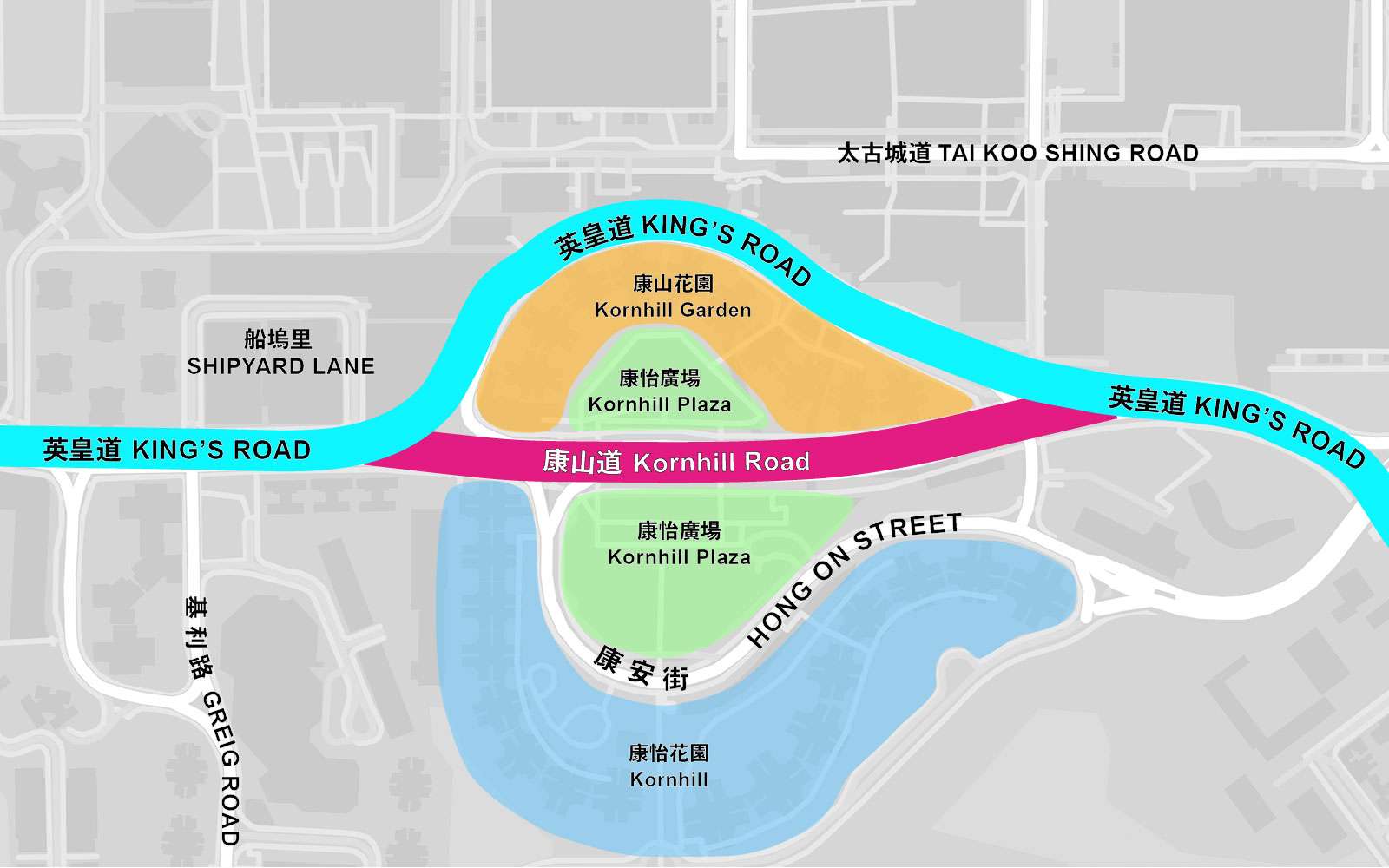
Until 1935 when it was renamed to commemorate the Silver Jubilee of King George V’s coronation, King’s Road was a part of Shau Kei Wan Road. Spanning from Causeway Bay to Shau Kei Wan, King’s Road is a major east-west thoroughfare on the eastern side of Hong Kong Island. However, there is a peculiarity in the section that links Quarry Bay with Tai Koo. Just past Shipyard Lane, Kornhill Road continues eastwards from King’s Road in a straight line, while King’s Road swings northwards. After about 270m, it loops back southwards and rejoins Kornhill Road, continuing onwards once again. This begs the question, why is there a segment called Kornhill Road sandwiched between a kink in King’s Road? Let’s look behind the street names to solve the mystery.
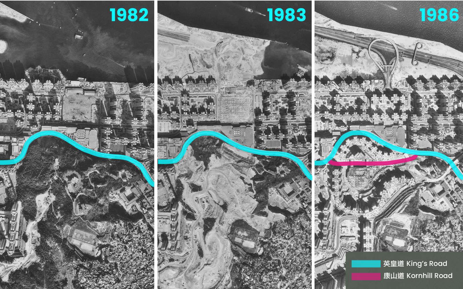
The process of levelling Kornhill for developing a large-scale residential project. Photo credit: Lands Department Open Data.
As the name “Kornhill Road” suggests, there was once a hill called Kornhill here. Before 1982, King’s Road and its tram tracks looped around the northern side of the hill on its way to Shau Kei Wan. Between 1982 and 1985, a large chunk of Kornhill was flattened to make way for a new residential area and Tai Koo MTR Station. The newly developed area included Kornhill Garden, Kornhill Plaza, and a new road. Initially, this new road was referred to as “the straightened section of King’s Road” or “New King’s Road”, but in 1986, the government decided to preserve the original King’s Road name to avoid changing any building addresses. As a result, the new segment would not be considered part of King’s Road and needed its own name. After discussions among various government departments, the new road was officially gazetted as “Kornhill Road” on 3 April 1987, forming the street layout we see today.
Fat Kwong Street serves as a major thoroughfare linking Hung Hom and Ho Man Tin, its total length running 1.3 kilometres. It goes from Man Yue Street in the industrial area of Hung Hom to Pui Ching Road where Ho Man Tin meets Mong Kok. When Fat Kwong Street was first gazetted in 1926, it was just a 200-metre-long minor street from Ma Tau Wai Road to Gillies Avenue (now Gillies Avenue North). At that time, Pui Ching Road had not yet been built, while Ho Man Tin was still an undeveloped valley that the government was planning to turn into a cemetery area.
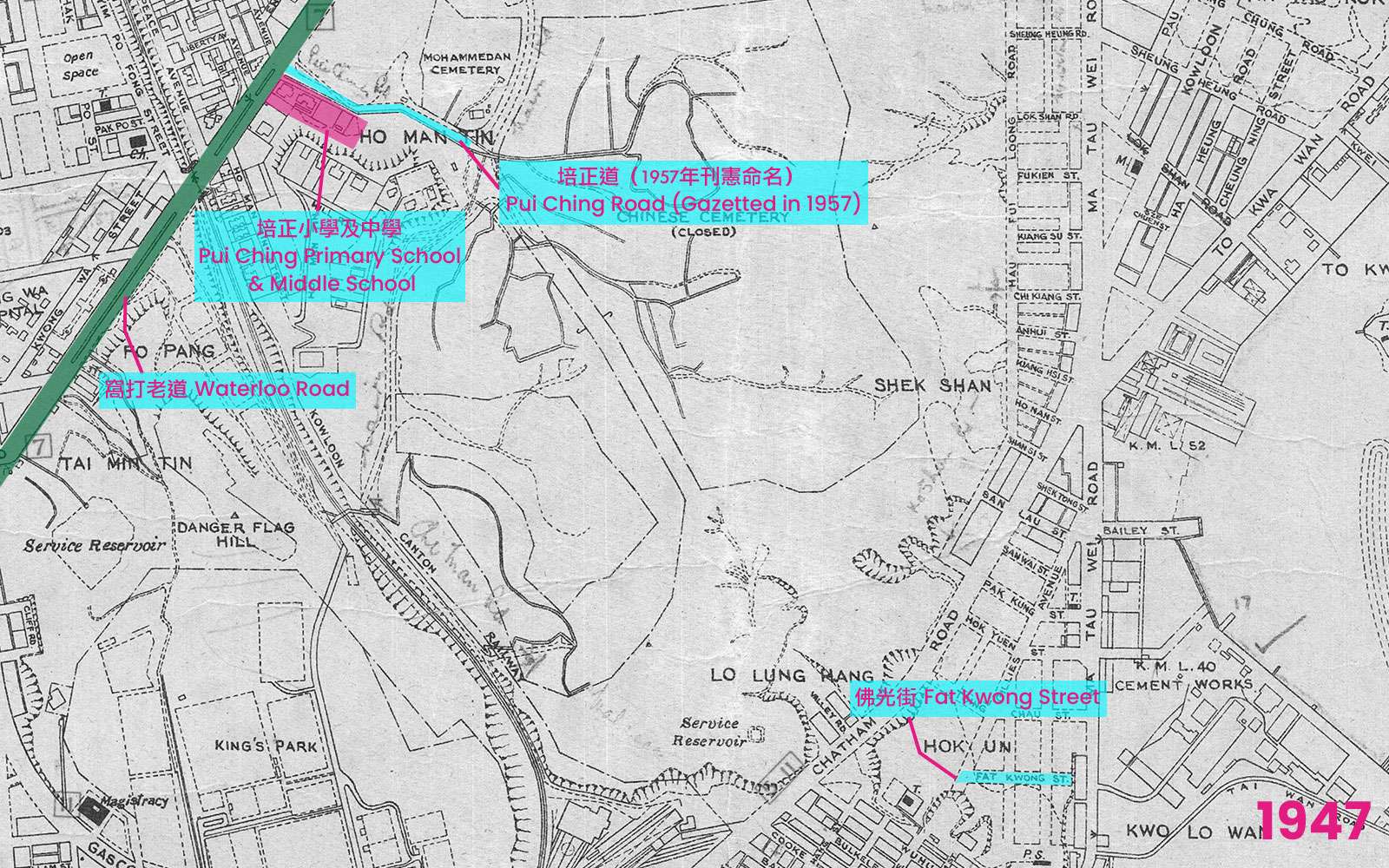
Map of Kowloon Peninsula, 1947. Pui Ching Road had yet to be named and gazetted, while Fat Kwong Street was a short local street in Hung Hom. The Chinese Cemetery in Ho Man Tin had been closed by this point. Source: hkmaps.hk.
In the early 1930s, the government sold land near Waterloo Road to the sponsoring body of Pui Ching School, which established its primary and secondary sections in 1933 and 1935, respectively. However, it was not until 1957 that the road just north of the school campus was named “Pui Ching Road”; it started at the junction of Waterloo Road and ran eastwards to Princess Margaret Road (known as Nairn Road before Princess Margaret’s 1966 visit). At that time, hilly terrain separated Fat Kwong Street and Pui Ching Road. After the war, the cemetery was replaced by squatters. Many refugees fled to Hong Kong from the mainland and began building huts of wood or stone along the hillsides in various parts of Kowloon and Hong Kong island. The government designated the Ho Man Tin Valley as an approved “Cottage Resettlement Area”, allowing charitable organizations to build huts for refugees. Looking at the 1960 map, we can see that as the resettlement area expanded, Pui Ching Road was extended and became the area’s major thoroughfare. It stretched past the intersection with Nairn Road to where Sheung Shing Street currently is, around Ho Man Tin Estate.

This survey sheet from 1960 shows that Pui Ching Road (marked in blue) once extended into the squatter settlement area east of Nairn Road/Princess Margaret Road (marked in pink). Source: Lands Department Open Data.
In 1962, the government announced a development scheme for Ho Man Tin Hill, which planned to clear over a thousand squatter huts, flatten the hills and resettle nearly 20,000 residents within a five-year period. This project aimed to free up over a hundred acres (40 ha) of land for private residential units, schools and public housing. On top of that, the development plan included the construction of a new road that would connect Princess Margaret Road to Chatham Road by extending Fat Kwong Street until it linked up with Pui Ching Road. An arch bridge would be built on its eastern side to provide access to Hung Hom.
Five years later, the Ho Man Tin Hill development scheme was behind schedule, and the design of the Fat Kwong Street and Pui Ching Road route was once again reworked. The route would connect the densely populated areas of Hung Hom, Ho Man Tin, and Mong Kok, and so was expected to carry heavy traffic. However, now with the upcoming opening of the Lion Rock Tunnel and new plans to build a cross-harbour tunnel in Hung Hom, traffic volumes were projected to increase significantly.
Hence, the Transport Advisory Committee suggested an alteration of the design. Instead connecting Princess Margaret Road, Pui Ching Road and Fat Kwong Street together with a roundabout, Pui Ching Road and Fat Kwong Street would meet as a flyover over Princess Margaret Road, with two connecting ramps allowing vehicles to turn on and off. This new design would create a high-capacity interchange, eliminating the need for traffic lights on Princess Margaret Road and maintaining the free flow of traffic. The flyover was opened in 1970, and Fat Kwong Street, which started out as a 200-metre-long local street, became a key route connecting Ho Man Tin and Hung Hom.
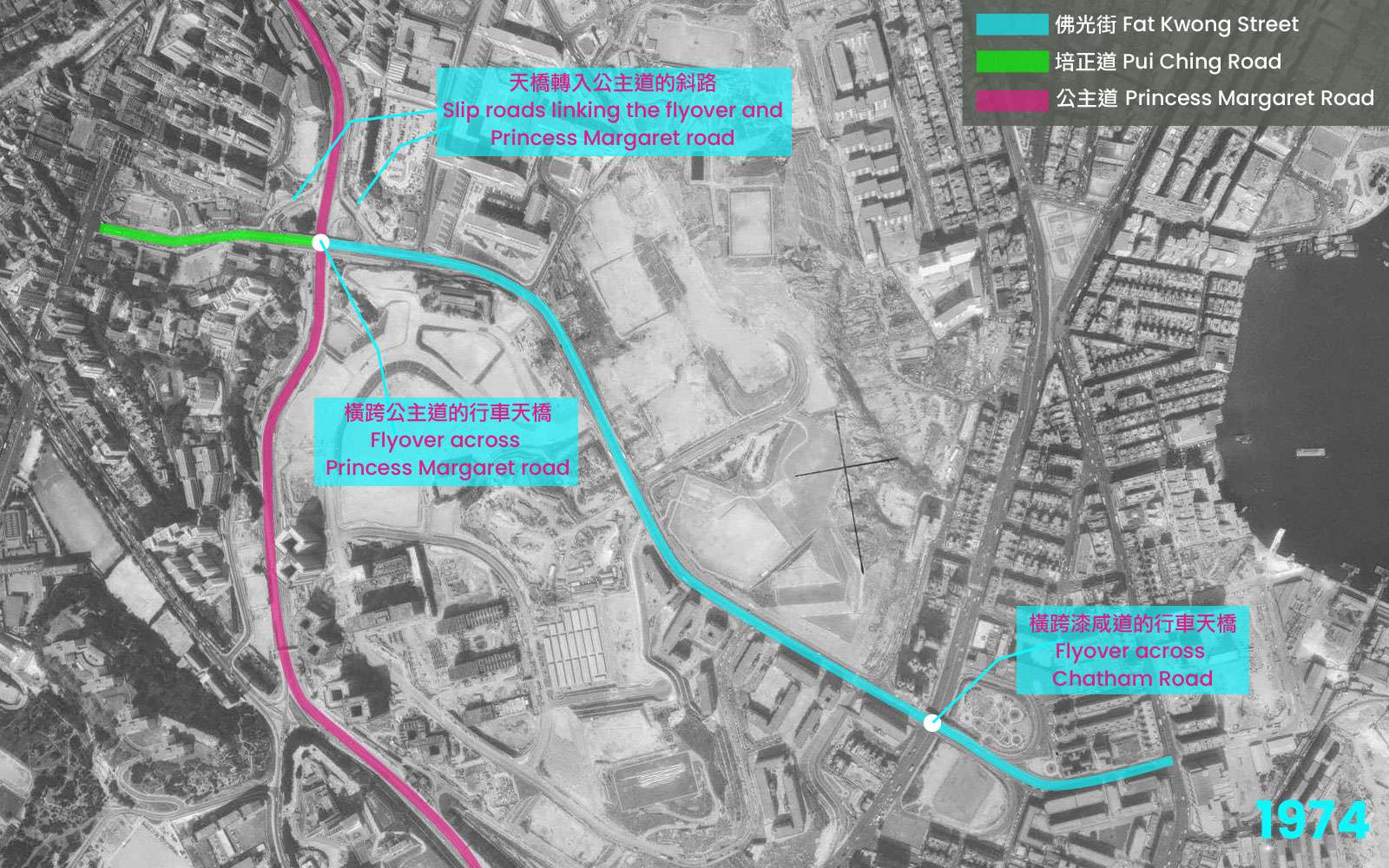
An aerial photo in 1974 shows that the section of Pui Ching Road east of Princess Margaret Road was straightened and became part of Fat Kwong Street. The two roads meet on the flyover across Princess Margaret Road, which was originally planned to be a roundabout. Photo credit: Lands Department Open Data.
Objectives behind urban development, including housing, transportation, commercial activity, and administration, evolve over time. These changes are often reflected in the names and layouts of streets, as the layout of streets shifts due to a city’s expansion and development. The current street network is, in fact, the culmination of multiple waves of urban development.
Director of Public Works, “Gazetting of Street Name – Wharf Road”, February 1951, HKRS477-3-22 Naming of Road, Streets, Etc, HKSAR Public Records Office.
“Public Works Programme, 1967/68 (First Review)”, May 1967, HKRS156-2-1721. Princess Margaret Rd./Pui Ching Rd., Junction – Improvements to…., HKSAR Public Records Office.
Director of Urban Services, “Naming of Street – Road in City Garden near City Garden Hotel”, 7 October 1991, HKRS1014-1-27 Naming of Streets in North Point, HKSAR Public Records Office.
District Officer (Eastern), “Naming of Street – Road in City Garden near City Garden Hotel”, 17 October 1991, HKRS1014-1-27 Naming of Streets in North Point, HKSAR Public Records Office.
Engineering (Highways), “Realignment of King’s Road at Kornhill”, 1984,
HKRS1443-2-45 KORNHILL DEVELOPMENT, HKSAR Public Records Office.
District Officer (Eastern), “Naming of Roads – Kornhill Development”, 12 March 1986, HKRS1443-4-46 Kornhill Development, HKSAR Public Records Office.
“Nga Tsin Wai Road, etc”, 26 June 1926, The Hongkong Government Gazette.
“Land Sale-Kowloon Inland Lot No. 2454, adjoining K.I.L. No. 1733, Waterloo Road”, 27 March 1931, The Hongkong Government Gazette.
“Land Sale-Kowloon Inland Lot No. 3056, adjoining K.I.L. No. 2454, Ho Mun Tin”, 10 November 1932, The Hongkong Government Gazette.
Hugh Farmer, “North Point Power Station”, The Industrial History of Hong Kong Group, 9 January 2023.
York Lo, “The Life and Family of S.M. Churn (張公勇, 1887-1959) of China Provident, Union Trading and Vibro”, The Industrial History of Hong Kong Group, 30 August 2021.
Development & Housing Committee of Shatin District Council, 〈街道命名通則〉(“General Principles of Street-naming”), 2 May 2019.
Kai Chi Leung,〈尋找何文田墳場原址〉(“Finding the original site of Ho Man Tin Cemetery”), 29 November 2022, Inmediahk.
Wing Yan Ng,〈代代相傳的「暗號」:你係培正人?你係咩社?〉(“The “secret code” passed down through generations: “Are you from Pui Ching? What house were you in?”), 6 October 2019, Ming Pao Weekly.
Information Services Department,〈何文田發展計劃完成 將成為九龍新中心〉(“The Ho Man Tin Development Plan is completed and will become the new center of Kowloon”), 8 July 1972, Government Records Service, XN000023.
Kung Sheung Daily News,〈交通諮詢會向當局建議 佛光街培正道與公主道連接〉(“Traffic Consultative Committee Proposes Connecting Fat Kwong Street and Pui Ching Road with Princess Margaret Road”), 28 April 1967.
An abandoned, hollowed out fire hydrant sits by an overgrown path in a forest. Its red paint, though..
If you walk down main roads in the New Territories, you might notice buildings called “Vegetable Depots” near..
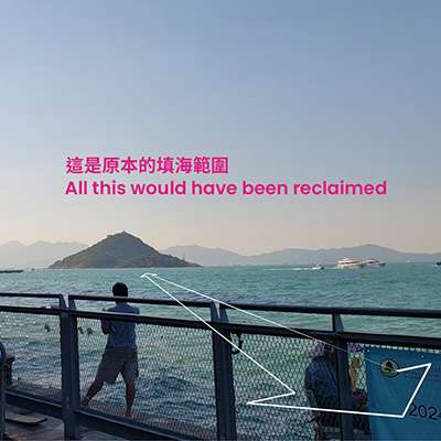
If you follow the Western Harbour Walk on the Hong Kong Island Coastal Trail, you will pass the..
The year is 1869. Hong Kong has been under British rule for 28 years, and it has been..
For the 2024/25 Coastal Trail Challenge, we are collaborating with Parks and Trails to highlight stories behind some..